


Le Vaudoué- lavande - 21km

jeanmarcMasson
User GUIDE
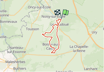

Length
21 km

Max alt
130 m

Uphill gradient
245 m
Km-Effort
24 km

Min alt
65 m

Downhill gradient
245 m
Boucle
Yes
Creation date :
2023-07-26 08:08:24.139
Updated on :
2023-07-26 14:03:10.33
4h39
Difficulty : Very difficult

FREE GPS app for hiking
 SityTrail
IGN / Geographical institutes
SityTrail Plus
The world is yours!
About
Trail Walking of 21 km to be discovered at Ile-de-France, Seine-et-Marne, Le Vaudoué. This trail is proposed by jeanmarcMasson.
Positioning
Country:
France
Region :
Ile-de-France
Department/Province :
Seine-et-Marne
Municipality :
Le Vaudoué
Location:
Unknown
Start:(Dec)
Start:(UTM)
464944 ; 5356828 (31U) N.
Comments